New Zealand, with its breath-taking landscapes and stunning natural beauty, boasts some of the world's most remarkable hiking trails. Among these, the Tongariro Alpine Crossing stands out as a pinnacle of outdoor adventure. In this blog post, we'll delve into the allure of this iconic day hike.
Located in the heart of the North Island, within the boundaries of Tongariro National Park, the Tongariro Alpine Crossing is renowned as one of New Zealand's best single-day hikes. Spanning approximately 19.4 kilometres (12 miles) from start to finish, the trail offers hikers an unforgettable journey as it weaves through a diverse range of landscapes, from volcanic craters to emerald lakes, steaming vents and lunar-like terrain.
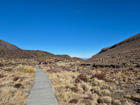
The journey begins at the Mangatepopo car park, approximately 18km from National Park Village, where eager hikers set foot on the trail, surrounded by the towering peaks of the Tongariro volcanic massif.
The first leg of the trek from Mangatepopo to the tranquil Soda Springs spans 7.2 kilometres. Initially, the path follows relatively flat terrain, followed by a gradual ascent which begins to reveal the rugged beauty of the surrounding volcanic landscapes. Along the way, hikers are treated to panoramic views of the imposing Mount Ngauruhoe, an iconic cone-shaped volcano famously known as Mount Doom from the "Lord of the Rings" trilogy. A 5-minute diversion to Soda Springs offers a rest stop with a small stream and lush vegetation.
Soda Springs to South Crater
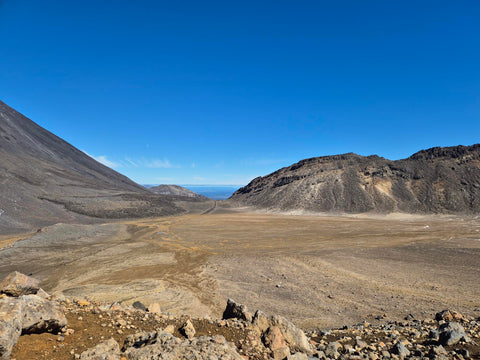
Continuing the journey from Soda Springs to South Crater, adventurers traverse 1.5 kilometres of rugged terrain, marked by a steeper ascent and rocky pathways. Amidst this challenging landscape, hikers are rewarded with breath-taking views of the surrounding volcanic peaks, including Mount Ngauruhoe and Mount Tongariro.
Upon reaching South Crater, you are greeted with a vast expanse of barren terrain, stretching between the majestic peaks of Ngauruhoe and Tongariro. This flat, desolate landscape offers a stark contrast to the lush valleys and slopes encountered earlier on the trail, serving as a reminder of the raw, untamed beauty of the Tongariro Crossing.
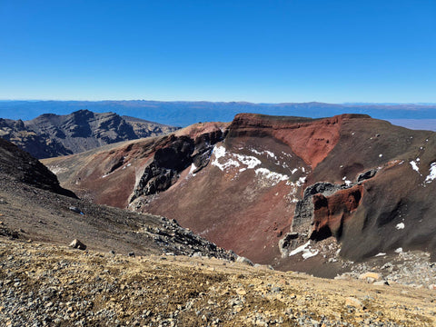
South Crater to Red Crater Summit
South Crater to Red Crater Summit is only 1 kilometre but involves a steep ascent. As adventurers navigate this challenging terrain, they are greeted by awe-inspiring vistas of the surrounding volcanic landscape, showcasing the rugged beauty of Tongariro National Park. The ultimate reward awaits at the Red Crater Summit, the highest point of the trail, where panoramic views of the park unfold in all directions.
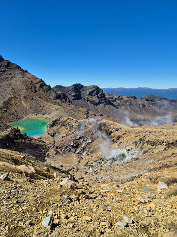
Red Crater Summit to Emerald Lakes
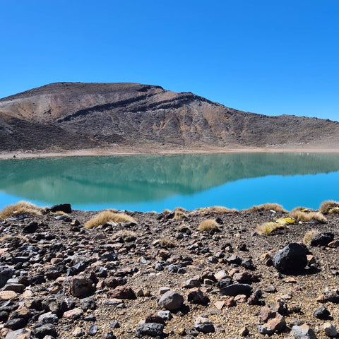
Descending from the summit, the trail leads hikers into a series of volcanic valleys, to the striking Emerald Lakes, a trio of vividly coloured pools, nestled within volcanic craters. The lakes captivate the senses with their vibrant hues, ranging from turquoise to emerald green and are formed by the leaching minerals from surrounding thermal activity.
Emerald Lakes to Blue Lake
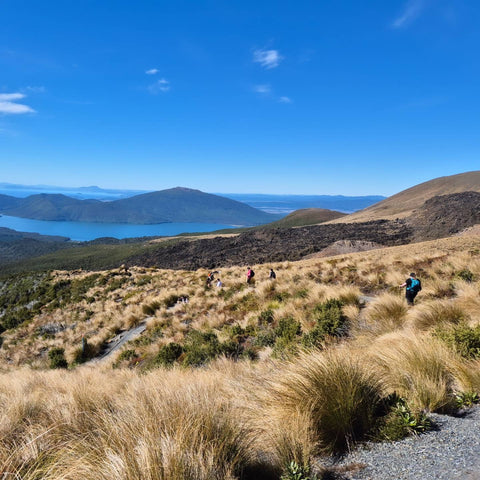
Continuing the journey from the Emerald Lakes to the serene beauty of Blue Lake, hikers navigate approximately 2.5 kilometres of varied terrain, encountering rocky sections and boardwalks along the way. The Blue Lake is revered as a sacred site by the indigenous Māori population, with its crystal-clear waters reflecting the surrounding volcanic features.
Blue Lake to Ketetahi Shelter:
As the trek progresses from Blue Lake to Ketetahi Shelter, hikers traverse approximately 3 kilometres of descending terrain, winding through alpine meadows and forested areas. Along the way, adventurers are treated to sweeping views of Lake Rotoaira shimmering in the distance, framed by the rugged peaks of the Kaimanawa Ranges.
This section of the trail culminates at Ketetahi Shelter, a welcome rest area offering basic facilities such as toilets and seating. Here, weary travellers can pause to replenish their energy and soak in the natural splendour of Tongariro National Park before continuing their exploration.
Ketetahi Shelter to Ketetahi Car Park
The final stretch of the Tongariro Alpine Crossing leads from Ketetahi Shelter to Ketetahi Car Park, covering approximately 3.5 kilometres of terrain characterised by a steep descent through lush, forested slopes. As hikers navigate this section, they are rewarded with captivating views of Ketetahi Hot Springs and the picturesque surrounding landscape.
Ketetahi Car Park marks the end of the crossing. Here, adventurers can take a moment to reflect on their experience while awaiting shuttle services to transport them back to their starting point.
Tongariro Alpine Crossing offers hikers an unforgettable journey through diverse volcanic landscapes, however, it's not without its challenges. The ever-changing weather can test even the most seasoned hikers and the steep ascents, descents and rocky terrain demand physical endurance and resilience. Lace up your boots, pack your sense of adventure, and prepare to be captivated by the majesty of the Tongariro Alpine Crossing.